Wondering what the channel is looking like?
Check out the live action camera overlooking the Motueka Channel from George Quay, courtesy of the TDC
TDC Harbour Master camera view
Please Note
3 knot speed limit applies in the immediate area of the marina and launch ramp.
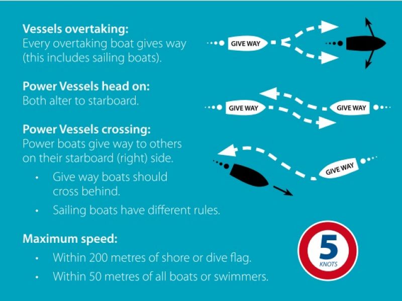
5 knot speed limit otherwise applies until 200 metres from shore.
The Motueka Power Boat Club ramp can be accessed by the general public by using the EFTPOS facility at the barrier arm. Currently the casual user fee is $15 (GST inclusive), subject to change.
When planning your passage throughout Tasman Bay it pays to be aware of the locations of the marine farms. For the most recent maps we recommend you check the Tasman District Council website.
Always keep an eye out as the farming areas are developing constantly.
All VHF radio users must monitor Channel 16 and hold an operator's certificate. Contact Coastguard Boating Education, www.boatingeducation.org.nz, for training or to register a callsign.
Users of Nelson Marine Radio's repeater channels 28 and 60 should subscribe to this service, email: nelson.marine.radio@gmail.com.
After making contact, boats wishing to converse should change to a working frequency. Channel 6 or 8 are suitable.
To contact a water taxi in the Abel Tasman area call:

Always keep a good lookout and travel at a safe speed.
Powerboats give way to sailing vessels and rowed or paddled vessels (e.g. kayaks).
In general, alter course to starboard (right) to avoid other vessels and keep a 50 metre buffer zone.
When on converging courses the vessel looking at the port (left side and red light) of the other vessel gives way. Best action is to alter course to starboard and pass behind the right of way (stand on) vessel. Stop if necessary.
All skippers should know Maritime Rule Part 22 -- Collision Prevention (appended to the Bylaw or see www.maritimenz.govt.nz, like all drivers should know the road code.
To contact the Tasman District Council Harbourmaster, phone 03 543 8400 or 03 5438433 DDI or 027 246 1904 mobile.

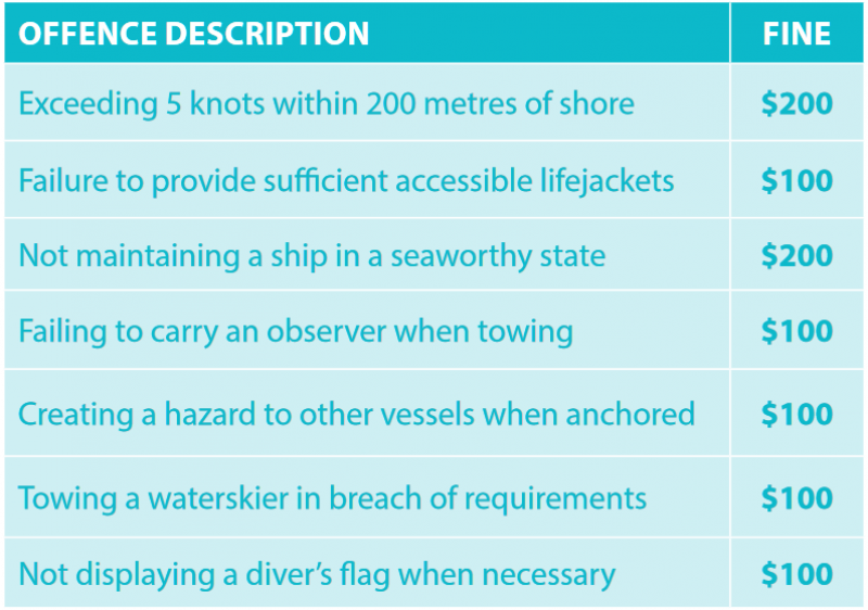
Tasman District Council Navigation Safety Bylaws include infringement (instant fines) provisions. Some of the instant fines that may be imposed are in the table.
